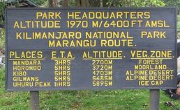
Photo: At Marangu Gate
MOUNTAIN KILIMANJARO TREKKING
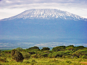
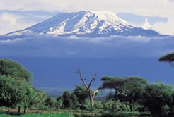
Snow-capped Kilimanjaro is Africa's highest mountain and the world's tallest of 19,340ft (5895 meters) above sea level. It has three major volcanic centers: Shira (4160m), Kibo (5895m) in the middle, and Mawenzi. The mountain can be climbed anytime of the year although the rainy season between mid March to end of May is not advised.
MARANGU ROUTE
Duration: 5 - 6 days hiking
Extra day on the mountain: $120/person
Low Season: $40 off in November and May 1-June 15
The Marangu route (Known as the "Tourist Route") is basically a long hike up a ridgeline to the top of Kilimanjaro. You can sleep in huts and even buy beer, coke, chocolates and other goodies along the way.
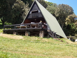
Photo: At Mandara Hut.
MARANGU ROUTE
DAY 1: MARANGU GATE (6497 FT) TO MANDARA HUT (8858 FT)
Elevation gain: 2361 ft Distance: approx. 4 miles Time: 4 - 5 hours
Your entire walk today will be through a beautiful rain forest up to Mandara Hut. The path will be muddy, especially if it has recently rained. The huts can accommodate approximately 80 people.
DAY 2: MANDARA HUT (8858 FT) TO HOROMBO HUT (12,204 FT)
Elevation gain: 3346 ft Distance:approx. 7 miles Time: 5-7 hours
The path takes you through giant heather as you make your way up to the moorland. Some portions of the trail are steep but you have a great view of Mawenzi peak. The Horombo huts sleep about 120 people. This is where you will meet people coming down from their summit attempts.
DAY 3: OPTION: One extra day and night at Horombo Hut for acclimatization. All meals and overnight in the hut.
OR
DAY 3 or 4: HOROMBO HUT (12,204 FT) TO KIBO HUT (15,430 FT)
Elevation gain: 3226 ft Distance: approx. 6 miles Time: 5-7 hours
Your hike today takes a gradual ascent past the Last Water point and up to the Saddle between the peaks of Kibo and Mawenzi. These huts sleep about 60 people and are more basic than the other huts. You will rest here before your summit attempt.
DAY 4 or 5: KIBO HUT (15,430 FT) TO UHURU PEAK (19,340 FT)
Elevation gain:3910 ft Distance: approx. 2.5 miles Time: 7-8 hours
Uhuru Peak (19,340 ft) to Horombo Hut (12,204 ft)
Elevation loss: 7136 ft Distance: approx. 9 miles Time: 5-7 hours
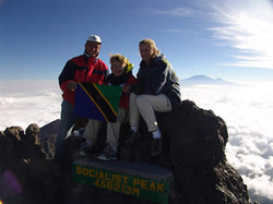
This is the longest day. At around 12:30 am, you will begin your summit attempt. The path up to Gillman’s Point, zigzags back and forth along a gravel path. This portion takes about 6 hours. Then you scramble over a few rocks and continue up to Uhuru Peak. After a few victorious photos, it’s time to head back down to Kibo Hut for a short rest before making your way down to Horombo Hut.
DAY 5 or 6: HOROMBO HUT (12,204 FT) TO MARANGU GATE (6496 FT)
Elevation gain: 5708 ft Distance:approx. 11 miles Time: 5-7 hours
Enjoy your last views of the mountain as you descend through the moorland and rain forest zones on your way to Marangu Gate. The path will be muddy, especially if it rained recently. At the gate, you will receive your completion certificate if you made it to Gillman’s Point or Uhuru Peak. Then it’s back to the hotel for a hot shower and a dip in the swimming pool!
INCLUDED :
Transport from Arusha to the gate and back
Park fees & Hut fees
Rescue fees
Park commission
Guide(s), cook and porters
All meals during the climb
EXCLUDED :
Beverages, Tips
Sleeping bag
Mt. Climbing gears
Items of personal nature
Dinner on the arrival day and lunch & dinner when back from the Mountain.
The prices are only for more than two person sharing room.
DAY 1: MARANGU GATE (6497 FT) TO MANDARA HUT (8858 FT)
Elevation gain: 2361 ft Distance: approx. 4 miles Time: 4 - 5 hours
Your entire walk today will be through a beautiful rain forest up to Mandara Hut. The path will be muddy, especially if it has recently rained. The huts can accommodate approximately 80 people.
DAY 2: MANDARA HUT (8858 FT) TO HOROMBO HUT (12,204 FT)
Elevation gain: 3346 ft Distance:approx. 7 miles Time: 5-7 hours
The path takes you through giant heather as you make your way up to the moorland. Some portions of the trail are steep but you have a great view of Mawenzi peak. The Horombo huts sleep about 120 people. This is where you will meet people coming down from their summit attempts.
DAY 3: OPTION: One extra day and night at Horombo Hut for acclimatization. All meals and overnight in the hut.
OR
DAY 3 or 4: HOROMBO HUT (12,204 FT) TO KIBO HUT (15,430 FT)
Elevation gain: 3226 ft Distance: approx. 6 miles Time: 5-7 hours
Your hike today takes a gradual ascent past the Last Water point and up to the Saddle between the peaks of Kibo and Mawenzi. These huts sleep about 60 people and are more basic than the other huts. You will rest here before your summit attempt.
DAY 4 or 5: KIBO HUT (15,430 FT) TO UHURU PEAK (19,340 FT)
Elevation gain:3910 ft Distance: approx. 2.5 miles Time: 7-8 hours
Uhuru Peak (19,340 ft) to Horombo Hut (12,204 ft)
Elevation loss: 7136 ft Distance: approx. 9 miles Time: 5-7 hours
This is the longest day. At around 12:30 am, you will begin your summit attempt. The path up to Gillman’s Point, zigzags back and forth along a gravel path. This portion takes about 6 hours. Then you scramble over a few rocks and continue up to Uhuru Peak. After a few victorious photos, it’s time to head back down to Kibo Hut for a short rest before making your way down to Horombo Hut.
DAY 5 or 6: HOROMBO HUT (12,204 FT) TO MARANGU GATE (6496 FT)
Elevation gain: 5708 ft Distance:approx. 11 miles Time: 5-7 hours
Enjoy your last views of the mountain as you descend through the moorland and rain forest zones on your way to Marangu Gate. The path will be muddy, especially if it rained recently. At the gate, you will receive your completion certificate if you made it to Gillman’s Point or Uhuru Peak. Then it’s back to the hotel for a hot shower and a dip in the swimming pool!
INCLUDED :
Transport from Arusha to the gate and back
Park fees & Hut fees
Rescue fees
Park commission
Guide(s), cook and porters
All meals during the climb
EXCLUDED :
Beverages, Tips
Sleeping bag
Mt. Climbing gears
Items of personal nature
Dinner on the arrival day and lunch & dinner when back from the Mountain.
The prices are only for more than two person sharing room.
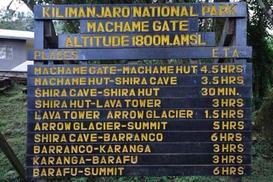
Photo: At Machame Gate
MACHAME ROUTE
Duration: 6 days hiking
Extra day on the mountain: $120/person
The Machame route ("Whiskey Route") is longer than the Marangu route and has some difficult days. However, it gives you more time to acclimate and offers some stunning views. It also has one of the highest success rates.
Duration: 6 days hiking
Extra day on the mountain: $120/person
The Machame route ("Whiskey Route") is longer than the Marangu route and has some difficult days. However, it gives you more time to acclimate and offers some stunning views. It also has one of the highest success rates.
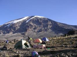
Photo: at Barranco
MACHAME ROUTE
DAY 1: MACHAME GATE (4888 FT) TO MACHAME CAMP (9776 FT)
Elevation gain: 4888 ft Distance: approx. 11 miles Time: 5 - 7 hours (depending on how wet the conditions are)
The first hour or so on the trail is a gradual climb through the beautiful rain forest As you ascend, the trail becomes steeper and you begin to navigate exposed tree roots sticking out of the ground. The Machame Camp is just beyond the edge of the forest and the Machame Hut.
DAY 2: MACHAME CAMP (9776 FT) TO SHIRA CAMP (12,598 FT)
Elevation gain: 2822 ft Distance: approx. 5.5 miles Time: 4 - 6 hours
Today’s climb is over rocks, little ones and big ones, as you make your way up to the Shira Plateau. The path is steep until lunch, afterwards becoming a more gradual incline towards Shira Camp. The large, exposed campground overlooks the town of Moshi.
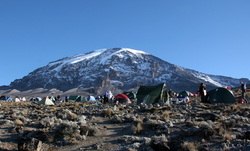
DAY 3: SHIRA CAMP (12,598 FT) TO BARRANCO CAMP (12,960 FT)
Elevation gain: 2592 ft(if going up to Lava Tower)
Distance: approx. 9 miles Time: 6 - 7 hours
This is your first day of “walk high, sleep low”, intended to help you acclimatize to the altitude. The grade is gradual as you make your way up to Lava Tower, but the way down to Barranco Camp is steep. Your camp is in the beautiful Barranco valley with large lobelia and senecio trees dotting the landscape.
DAY 4: BARRANCO CAMP (12,960 FT) TO BARAFU CAMP (14,928 FT)
Elevation gain: 1968 ft Distance: approx. 8 miles Time: 7 hours
You start the morning with a climb up the great Barranco wall, with some parts requiring a bit of scrambling over the rocks. Then it is about a 2-hour walk down to Karanga valley where you will have lunch. After a rest, you continue up to Barafu camp, where you will rest before the big summit attempt.
While the overall elevation gain is only about 2,000' feet you will actually climb more like 3,700' since you climb up the Barranco wall, hike down into the Karanga valley, and then back up to Barafu camp.
** On this day you have the option of going to Barafu Camp and up Stella Point or to Arrow Glacier and up the Western Breach Wall. The Breach is a steeper but a shorter summit climb.
DAY 5: BARAFU CAMP (14,928 FT) TO UHURU PEAK (19,340 FT)
Elevation gain: 4,412 ft Distance: approx. 4 miles Time: 5 - 7 hours
UHURU PEAK (19,340 FT) TO MWEKA CAMP (10,171 FT)
Elevation loss: 9,169 ft Distance: approx. 14 miles Time: 6 - 8 hours
This is the longest day. At around 12:30 am, you will begin your summit attempt. The path up to Stella Point zigzags back and forth along a gravel path. This portion takes about 6 hours. This can be quite boring as most of the hiking is in darkness with little to see. Then you scramble over a few rocks and continue up to Uhuru Peak. After a few victorious photos, it’s time to head back down to Barafu for a short rest before making your way down to Mweka camp.
DAY 6: MWEKA CAMP (10,171 FT) TO MWEKA GATE (6496 FT)
Elevation loss: 3675 ft Distance: approx. 9 miles Time: 3 - 4 hours (depending on how wet the conditions are)
Enjoy your last views of the mountain as you descend through the moorland and rain forest zones on your way to Mweka Gate. The path will be muddy, especially if it rained recently. At the gate, you will receive your completion certificate if you made it to Stella Point or Uhuru Peak. Then it’s back to the Hotel for dinner and overnight.
INCLUDED :
Transport from Arusha to the gate and back
Park fees & camping fees
Rescue fees
Park commission
Guide(s), cook and porters
Tents and mattresses
All meals during the climb
EXCLUDED :
Beverages, Tips
Sleeping bag
Dinner on the arrival day and lunch & dinner when back from the Mountain.
Items of personal nature e.g. telephone, cigarette etc.
The price quoted is for person sharing a tent.
DAY 1: MACHAME GATE (4888 FT) TO MACHAME CAMP (9776 FT)
Elevation gain: 4888 ft Distance: approx. 11 miles Time: 5 - 7 hours (depending on how wet the conditions are)
The first hour or so on the trail is a gradual climb through the beautiful rain forest As you ascend, the trail becomes steeper and you begin to navigate exposed tree roots sticking out of the ground. The Machame Camp is just beyond the edge of the forest and the Machame Hut.
DAY 2: MACHAME CAMP (9776 FT) TO SHIRA CAMP (12,598 FT)
Elevation gain: 2822 ft Distance: approx. 5.5 miles Time: 4 - 6 hours
Today’s climb is over rocks, little ones and big ones, as you make your way up to the Shira Plateau. The path is steep until lunch, afterwards becoming a more gradual incline towards Shira Camp. The large, exposed campground overlooks the town of Moshi.
DAY 3: SHIRA CAMP (12,598 FT) TO BARRANCO CAMP (12,960 FT)
Elevation gain: 2592 ft(if going up to Lava Tower)
Distance: approx. 9 miles Time: 6 - 7 hours
This is your first day of “walk high, sleep low”, intended to help you acclimatize to the altitude. The grade is gradual as you make your way up to Lava Tower, but the way down to Barranco Camp is steep. Your camp is in the beautiful Barranco valley with large lobelia and senecio trees dotting the landscape.
DAY 4: BARRANCO CAMP (12,960 FT) TO BARAFU CAMP (14,928 FT)
Elevation gain: 1968 ft Distance: approx. 8 miles Time: 7 hours
You start the morning with a climb up the great Barranco wall, with some parts requiring a bit of scrambling over the rocks. Then it is about a 2-hour walk down to Karanga valley where you will have lunch. After a rest, you continue up to Barafu camp, where you will rest before the big summit attempt.
While the overall elevation gain is only about 2,000' feet you will actually climb more like 3,700' since you climb up the Barranco wall, hike down into the Karanga valley, and then back up to Barafu camp.
** On this day you have the option of going to Barafu Camp and up Stella Point or to Arrow Glacier and up the Western Breach Wall. The Breach is a steeper but a shorter summit climb.
DAY 5: BARAFU CAMP (14,928 FT) TO UHURU PEAK (19,340 FT)
Elevation gain: 4,412 ft Distance: approx. 4 miles Time: 5 - 7 hours
UHURU PEAK (19,340 FT) TO MWEKA CAMP (10,171 FT)
Elevation loss: 9,169 ft Distance: approx. 14 miles Time: 6 - 8 hours
This is the longest day. At around 12:30 am, you will begin your summit attempt. The path up to Stella Point zigzags back and forth along a gravel path. This portion takes about 6 hours. This can be quite boring as most of the hiking is in darkness with little to see. Then you scramble over a few rocks and continue up to Uhuru Peak. After a few victorious photos, it’s time to head back down to Barafu for a short rest before making your way down to Mweka camp.
DAY 6: MWEKA CAMP (10,171 FT) TO MWEKA GATE (6496 FT)
Elevation loss: 3675 ft Distance: approx. 9 miles Time: 3 - 4 hours (depending on how wet the conditions are)
Enjoy your last views of the mountain as you descend through the moorland and rain forest zones on your way to Mweka Gate. The path will be muddy, especially if it rained recently. At the gate, you will receive your completion certificate if you made it to Stella Point or Uhuru Peak. Then it’s back to the Hotel for dinner and overnight.
INCLUDED :
Transport from Arusha to the gate and back
Park fees & camping fees
Rescue fees
Park commission
Guide(s), cook and porters
Tents and mattresses
All meals during the climb
EXCLUDED :
Beverages, Tips
Sleeping bag
Dinner on the arrival day and lunch & dinner when back from the Mountain.
Items of personal nature e.g. telephone, cigarette etc.
The price quoted is for person sharing a tent.
Photo: At Umbwe gate.
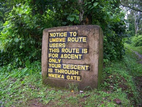
UMBWE KILI ROUTE
Duration: 5 days hiking
Extra day on the mountain: $130/person
The Umbwe route is the toughest non-technical route up Kilimanjaro. It is very steep and you gain elevation quickly. This route is not recommended for those who do not have serious mountain climbing experience. An extra day to help in acclimatization is also recommended.
Photo: At Karanga Valley.
UMBWE ROUTE
DAY 1: UMBWE GATE (4,593 FT) TO CAMP 1 (9,843 FT)
Elevation gain: 5,250 ft Distance: approx. 7 miles Time: 5 - 6 hours
Your climb today is through the beautiful rain forest The path is very steep and muddy. This route is normally used as a descent route and is rarely traveled. There are often exposed tree roots sticking out of the ground that must be navigated. Your camp is near the Umbwe Cave.
DAY 2: CAMP 1 (9,843 FT) TO BARRANCO CAMP (12,960 FT)
Elevation gain: 3,117 ft Distance: approx. 4 miles Time: 4 - 5 hours
The path continues it's steep climb through the rain forest, up through the heather and moorland to Barranco Camp. There are some sections where you will need to scramble over rocks. Your camp is in the beautiful Barranco valley with large lobelia and senecio trees dotting the landscape.
DAY 3: BARRANCO CAMP (12,960 FT) TO BARAFU CAMP (14,928 FT)
Elevation gain: 1,968 feet Distance: approx. 8 miles Time: 7 hours
You start the morning with a climb up the great Barranco wall, with some parts requiring a bit of scrambling over the rocks. Then it is about a 2-hour walk down to Karanga valley where you will have lunch. After a rest, you continue up to Barafu camp, where you will rest before the big summit attempt.
While the overall elevation gain is only about 2,000' feet you will actually climb more like 3,700' since you climb up the Barranco wall, hike down into the Karanga valley, and then back up to Barafu camp.
** On this day you have the option of going to Barafu Camp and up Stella Point or to Arrow Glacier and up the Western Breach Wall. The Breach is a steeper but a shorter summit climb.
DAY 5: BARAFU CAMP (14,928 FT) TO UHURU PEAK (19,340 FT)
Elevation gain: 4,412 ft Distance: approx. 4 miles Time: 5 - 7 hours
UHURU PEAK (19,340 FT) TO MWEKA CAMP (10,171 FT)
Elevation loss: 9,169 ft Distance: approx. 14 miles Time: 6 - 8 hours
This is the longest day. At around 12:30 am, you will begin your summit attempt. The path up to Stella Point zigzags back and forth along a gravel path. This portion takes about 6 hours. This can be quite boring as most of the hiking is in darkness with little to see. Then you scramble over a few rocks and continue up to Uhuru Peak. After a few victorious photos, it’s time to head back down to Barafu for a short rest before making your way down to Mweka camp.
DAY 6: MWEKA CAMP (10,171 FT) TO MWEKA GATE (6496 FT)
Elevation loss: 3,675 ft Distance: approx. 9 miles Time: 3 - 4 hours (depending on how wet the conditions are)
Enjoy your last views of the mountain as you descend through the moorland and rain forest zones on your way to Mweka Gate. The path will be muddy, especially if it rained recently. At the gate, you will receive your completion certificate if you made it to Stella Point or Uhuru Peak. Then it’s back to the hotel for dinner and overnight.
Umbwe starts on the "Machame side" of the mountain but is a more direct route
INCLUDED:
Transport from Arusha to the gate and back
Park fees & camping fees
Rescue fees
Park commission
Guide(s), cook and porters
Tents and mattresses
All meals during the climb
EXCLUDED:
Beverages, Tips
Sleeping bag
Mt. Climbing gears
Items of personal nature
Dinner on the arrival day and lunch & dinner when back from the Mountain.
The price quoted is for person sharing a tent.
Photo: On the way to Mti Mkubwa
LEMOSHO KILI ROUTE:
Duration: 7 days hiking
Extra day on the mountain: $120/person
Both the Shira and Lemosho routes are particularly beautiful and go through one of the few areas on the mountain rich in wildlife. Both start on the West side before meeting up with the Machame route at Shira camp after a few days. These routes offer more time to acclimate and stunning views.
Photo: At Shira camp
LEMOSH ROUTE
DAY 1: LONDOROSSI GATE ( 6890 FT ) TO MTI MKUBWAS CAMP ( 9022 FT)
Elevation gain: 2132 ft Distance: approx. 4 miles Time: 3 - 4 hours
After a 2 hour drive from Moshi to Londorossi gate, you follow a forest track requiring a 4WD vehicle. This leads to the Lemosho Glades (6,890ft) and a possible campsite (park fees are not paid to camp here). Most groups continue on to Mti Mkubwas Camp.
DAY 2: MTI MKUBWAS CAMP (9022 FT ) TO SHIRA 2 CAMP (12,598 FT )
Elevation gain: 3576 ft Distance: approx. 8 miles Time: 8 -9 hours
Your hike today continues through the forest and then into the heather and moorland areas up to the Shira Plateau. This camp is large and exposed with beautiful views of the town of Moshi and the Heim Glacier.
DAY 3: SHIRA 2 CAMP (12,598 FT) TO BARRANCO CAMP (14,928 FT)
Elevation gain: 2330 ft Distance: approx. 9 miles Time: 7 hours
This is your first day of “walk high, sleep low”, intended to help you acclimatize to the altitude. The grade is gradual as you make your way up to Lava Tower, but the way down to Barranco Camp is steep. Your camp is in the beautiful Barranco valley with large lobelia and senecio trees dotting the landscape.
DAY 4: BARRANCO CAMP (12,960 FT) TO BARAFU CAMP (14,928 FT)
Elevation gain: 1968 ft Distance: approx. 8 miles Time: 7 hours
You start the morning with a climb up the great Barranco wall, with some parts requiring a bit of scrambling over the rocks. Then it is about a 2 hour walk down to Karanga valley where you will have lunch. After a rest, you continue up to Barafu camp, where you will rest before the big summit attempt.
While the overall elevation gain is only about 2,000' feet you will actually climb more like 3,700' since you climb up the Barranco wall, hike down into the Karanga valley, and then back up to Barafu camp.
** On this day you have the option of going to Barafu Camp and up Stella Point or to Arrow Glacier and up the Western Breach Wall. The Breach is a steeper but a shorter summit climb.
DAY 5: BARAFU CAMP (14,928 FT) TO UHURU PEAK (19,340 FT)
Elevation gain: 4,412 ft Distance: approx. 4 miles Time: 5 - 7 hours
UHURU PEAK (19,340 FT) TO MWEKA CAMP (10,171 FT)
Elevation loss: 9,169 ft Distance: approx. 14 miles Time: 6 - 8 hours
This is the longest day. At around 12:30 am, you will begin your summit attempt. The path up to Stella Point zigzags back and forth along a gravel path. This portion takes about 6 hours. This can be quite boring as most of the hiking is in darkness with little to see. Then you scramble over a few rocks and continue up to Uhuru Peak. After a few victorious photos, it’s time to head back down to Barafu for a short rest before making your way down to Mweka camp.
DAY 6: MWEKA CAMP (10,171 FT) TO MWEKA GATE (6496 FT)
Elevation loss: 3675 ft Distance: approx. 9 miles Time: 3 - 4 hours (depending on how wet the conditions are)
Enjoy your last views of the mountain as you descend through the moorland and rain forest zones on your way to Mweka Gate. The path will be muddy, especially if it rained recently. At the gate, you will receive your completion certificate if you made it to Stella Point or Uhuru Peak. Then it’s back to the hotel for dinner and overnght.
The moorland turns to dirt and rock after Karanga camp, on the way to Barafu camp.
INCLUDED:
Transport to be paid by the client.
Park fees & camping fees
Rescue fees
Park commission
Guide(s), cook and porters
Tents and mattresses
All meals during the climb
EXCLUDED:
Beverages, Tips
Sleeping bag
Mt. Climbing gears
Items of personal nature
Dinner on the arrival day and lunch & dinner when back from the Mountain.
The price quoted is for person sharing a tent.
MOUNT MERU
MERU TREK
Duration: 4 or 3 days hiking as you can see below
Mount Meru is the second highest mountain in Tanzania at 4,5685m; at 14,977’ above the sea level,and the fifth highest in Africa. It is best to allow three days for climbing Merusince it involves a 3,500m altitude trek. There are two huts available to climbers on the mountain and firewood is supplied. The best time to climb Meru is between October and February. The mountain is usually climbed from Olkokola on the western side of the crater and you need a park ranger as an escort due to the threat of buffalo.
Meru is also a great way to warm up and adjust to the altitude before hitting Kilimanjaro.
4 DAYS/3 DAYS
MERU CLIMBING
4 DAY ITINERARY:
DAY 1: MOMELA GATE (4,921 FT) TO MIRIAKAMBA HUT (8,250 FT)
Elevation gain: 3,329ft Distance: approx. 6 miles Time: 4-6 hours
From the Momela Gate you wind through the forest and past the famous "Fig Tree". As you make you way past Itikoni clearing you may see wild buffalo grazing. As you continue to ascend you'll reach Kitoto camp with wonderful views of Kilimanjaro and the Momela lakes. About 1 hour later you should reach Miriakamba
Hut and your camp for the night. You can also walk to the Meru Crater floor in 2-3 hours from here if you still have some energy
DAY 2: MIRIAKAMBA HUT (8,250 FT) TO SADDLE HUT (11,500 FT)
Elevation gain: 2887 ft Distance: approx. 3 miles Time: 2-4 hours
From Miriakamba Hut the trail climbs steeply through glades and trees. After the hour or so you'll have some great views into the crater and up the cliff walls below the summit. Finally, you cross some grassy clearings and a few stream beds to reach Saddle Hut
DAY 3: SADDLE HUT (11,500 FT) TO SUMMIT (14,977 FT)
Elevation gain: 3,477 ft Distance: approx. 3 miles Time: 4-5 hours
After breakfast, you continue the ascent to the summit (14,977 ft). After enjoying a few minutes on top of Meru you descend back to 11,500 ft. Here you rest and take a relaxing lunch before continuing down to 8,497 ft for dinner and one more night at the camp site.
DAY 4: MIRIAKAMBA HUT (8,497 FT) TO MOMELA GATE (4,921 FT)
Elevation loss: 3,524 ft Distance: approx. 6 miles Time: 4-5 hours
After breakfast, we continue the descent down through the rain forest to the base of Mount Meru. The drive back to our hotel in Arusha takes about 1 hour.
Meru, in distance, offers great views of Kilimanjaro
3 DAY ITINERARY:
This itinerary combines the first 2 days to go directly to the Saddle Hut (11,500 ft) in one day. The summit and descent is the same as the 4 day options after Saddle Hut.
DAY 1: MOMELA GATE (4,921 FT) TO SADDLE HUT (11,500 FT)
Elevation gain: 6579 ft Distance: approx. 8 miles Time: 7-8 hours
You start the morning with a drive from Moshi first thing in the morning and start the climb in Arusha National Park from the Momela Gate. You start your climb at the base of Mount Meru and continue on a path through the rain forest to the first camp at 11,500 ft. If you have enough time you may also climb Little Meru for a great view of Kilimanjaro and to assist with your acclimatization.
INCLUDED:
Transport to and fro the gate.
Park fees & camping fees
Rescue fees
Park commission
Guide(s), cook and porters
Tents and mattresses
All meals during the climb
EXCLUDED:
Beverages, Tips
Sleeping bag
Mt. Climbing gears
Items of personal nature
Dinner on the arrival day and lunch & dinner when back from the Mountain.
The price quoted is for person sharing.
CULTURAL TREKKING SAFARIS
CULTURAL TREKKING SAFARIS
NGORONGORO HIGHLANDS
6DAYS/5NIGHTSDAY
Day 1: Depart Arusha in the morning for transfer to the Ngorongoro Crater. Descend into the crater for full day game viewing, with picnic lunch on the crater floor. Come out of the crater on the other side in the late afternoon and proceed to Nainokanoka for camping. Donkeys and Masai donkey drivers are taken here.
DAY 2: Start of the trekking. The luggage is carried by donkeys. Walk up to the Empakai Crater rim, where you'll camp.
DAY 3: Descend into the Empakai crater, and continue trekking through a magnificent landscape to Naiyobi village for camping. OlDoinyo Lengai and Mount Meru are seen along the way
DAY 4: The trek continues up to "Pembe ya Swala" for camping on the foothills of OlDoinyo Lengai.
DAY 5: Shortly after midnight start climbing the volcano. The summit is reached by sunrise. After descending you'll be pick-up again by your car for transfer to Kamakia Camp, near the shores of Lake Natron. After a rest, walk to the waterfalls for a swim.
DAY 6: You might take a walk to the shores of Lake Natron, a breeding place for thousands of flamingos. Giraffes or other animals are often seen in this area.
Return to Arusha in the afternoon, or proceed on a safari.
UDZUNGWA
UDZUNGWA MOUNTAIN
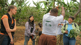
Trekking Udzungwa Mountains is an easily practice that will lead you from Mangula through Mwanihana trail and Sanje trail, enjoying Sanje waterfalls, butter flies crested mangabey and Iringa red colobus, on your way overlooking Kilombero valley.
Udzungwa Mwanihana Trail
Day 1: Dar es salaam - Mangula
Our Safari driver guide will pick you up from your Dar es Salaam hotel in the morning after breakfast and drive you to Mangula. The drive will take you around 6 hours. Spend the rest of the afternoon relaxing at the campsite or have a village tour. Dinner and overnight at Hondo campsite or Hondo mud hut bandas.
Day 2: Mangula - Sanje waterfall
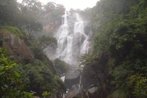
In the morning after breakfast, walk to the park Headquarters. After briefing, transfer to the start of the Sanje Trail. Hike into the pristine Eastern Arc forest looking for endemic primates including the Sanje Crested Mangabey and the Iringa red Colobus. Arrive at the top of the 180m Sanje waterfall. Have the opportunity to relax at idyllic plunge pools and see endemic African violets growing in the spray zones. Enjoy a spectacular lunch; overlooking the Kilombero Valley, descend in the afternoon looking for primates and transfer to Hondo Campsite Hondo mud hut bandas for dinner and overnight.
Day 3: Sanje waterfall - Mwanihana trail
After breakfast you will transfer to the village of Sonjo and begin the Mwanihana trek. An armed park ranger will accompany you because there are numerous elephant and buffalo in the area. As you trek, study the tracks and signs in the forest and various medicinal plants. Reach Njia Ya Panda (the 'climbing path'). Check into the Campsite where you will have dinner and overnight.
Day 4: Udzungwa Mountains - Back to the gate.
Early breakfast, trek through the changing forest until you reach the summit of Mwanihana. Encounter true montane vegetation amongst the Giant Ericas. Below you will view a spider’s web of elephant trails crisscrossing the park. Descend and trek through the forest until you reach your camp for the night.
Trekking Udzungwa Mountains is an easily practice that will lead you from Mangula through Mwanihana trail and Sanje trail, enjoying Sanje waterfalls, butter flies crested mangabey and Iringa red colobus, on your way overlooking Kilombero valley.
Udzungwa Mwanihana Trail
Day 1: Dar es salaam - Mangula
Our Safari driver guide will pick you up from your Dar es Salaam hotel in the morning after breakfast and drive you to Mangula. The drive will take you around 6 hours. Spend the rest of the afternoon relaxing at the campsite or have a village tour. Dinner and overnight at Hondo campsite or Hondo mud hut bandas.
Day 2: Mangula - Sanje waterfall
In the morning after breakfast, walk to the park Headquarters. After briefing, transfer to the start of the Sanje Trail. Hike into the pristine Eastern Arc forest looking for endemic primates including the Sanje Crested Mangabey and the Iringa red Colobus. Arrive at the top of the 180m Sanje waterfall. Have the opportunity to relax at idyllic plunge pools and see endemic African violets growing in the spray zones. Enjoy a spectacular lunch; overlooking the Kilombero Valley, descend in the afternoon looking for primates and transfer to Hondo Campsite Hondo mud hut bandas for dinner and overnight.
Day 3: Sanje waterfall - Mwanihana trail
After breakfast you will transfer to the village of Sonjo and begin the Mwanihana trek. An armed park ranger will accompany you because there are numerous elephant and buffalo in the area. As you trek, study the tracks and signs in the forest and various medicinal plants. Reach Njia Ya Panda (the 'climbing path'). Check into the Campsite where you will have dinner and overnight.
Day 4: Udzungwa Mountains - Back to the gate.
Early breakfast, trek through the changing forest until you reach the summit of Mwanihana. Encounter true montane vegetation amongst the Giant Ericas. Below you will view a spider’s web of elephant trails crisscrossing the park. Descend and trek through the forest until you reach your camp for the night.
